GIS for Coastal Engineering
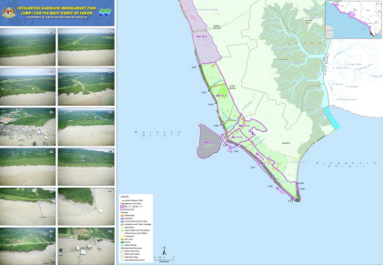
GIS technology has been applied as an effective means to comply with Integrated Shoreline and Coastal Zone Management needs and requirements. Integrated Shoreline Management Plan (ISMP) provides a largescale assessment of the risks associated with coastal processes and presents a policy framework to reduce these risks to people and the developed, historic and natural environment in a sustainable manner. Integrated Coastal Zone Management (ICZM) is a dynamic, multidisciplinary and iterative process to promote sustainable management of coastal zones. It covers the full cycle of information collection, planning (in its broadest sense), decision making, management and monitoring of implementation.
Decision Support System
The use of GIS not only improves the analytical capabilities for Integrated Shoreline and Coastal Zone data management but also the ability to communicate the study results and findings to the decision makers. The use of GIS in coastal engineering works: GIS for Civil engineering is about developing and sustaining infrastructure. Geographic Information System (GIS) technology provides the tools for creating, managing, analysing, and visualizing the data associated with developing and managing infrastructure. GIS allows civil engineers to manage and share data and turn it into easily understood reports and visualizations that can be analysed and communicated to others. The use of GIS in infrastructural and civil engineering works:
- Data management
- Infrastructure management
- Site analysis
- Borehole data management and analysis
- Critical infrastructure protection
- Slope stability analysis
- Slope management system
- Planning and site location
- Environmental analysis & Civil Engineering Infrastructural GIS for Coastal Engineering
- Infrastructure design
- Construction management
- Data collection and as-built surveying
- Operations and maintenance
- Data management
- Design works
- Hydraulic modelling
- Landuse planning
- Prior to and during construction
- During interim and final
- Reclamation
- Long-term monitoring and analysis
- Field navigation